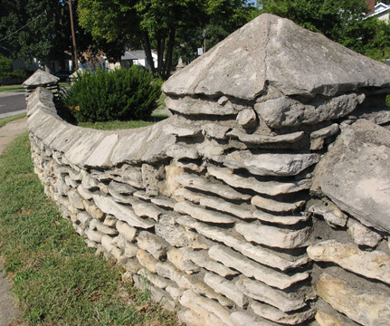
Most Maplewoodians are familiar with and appreciate this stone wall that is on Flora just west of Big Bend. The wall is rubble of course. The flat stones used for the top of the wall (called coping) and in the squat columns I have heard referred to as flagstones.
The amount of interest in the first Let’s Go Get Stoned article is amazing and gratifying. I hadn’t realized how many stoners there are amongst us. Many of you have asked questions. I hope this post and the next one (or possibly two) will answer most of them.
One question I had awhile back concerned a type of limestone called St. Louis. I thought that surely this must be the white limestone that we see everywhere in foundations, walls, stairs, columns and houses etc. here in St. Louis. I recall looking on the internet for an answer but couldn’t find a conclusive one.
I had been given an opinion earlier that the highly visible white limestone is not St. Louis limestone. The limestone known by that name is of a lower grade than this favorite of ours. This might be true. If it is I propose we switch names with whatever the white limestone is called now and the lower grade. I’d love to be able to brag to visitors and guests that the beautiful stonework they see everywhere is made from St. Louis limestone. Maybe I’ll do it anyway.
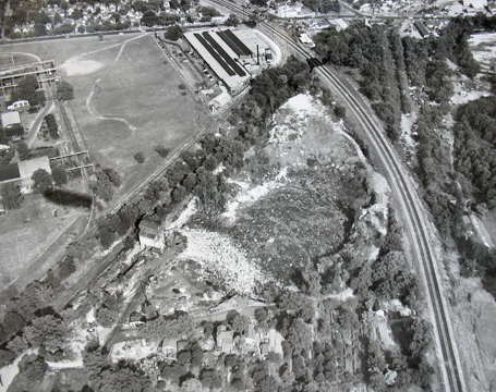
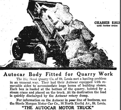
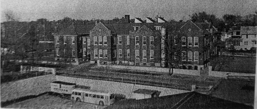
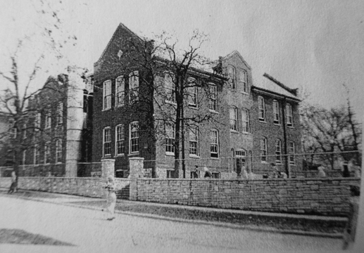
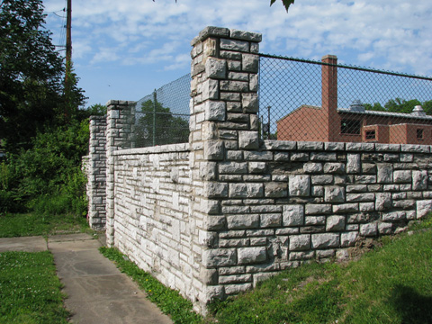
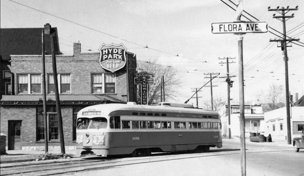
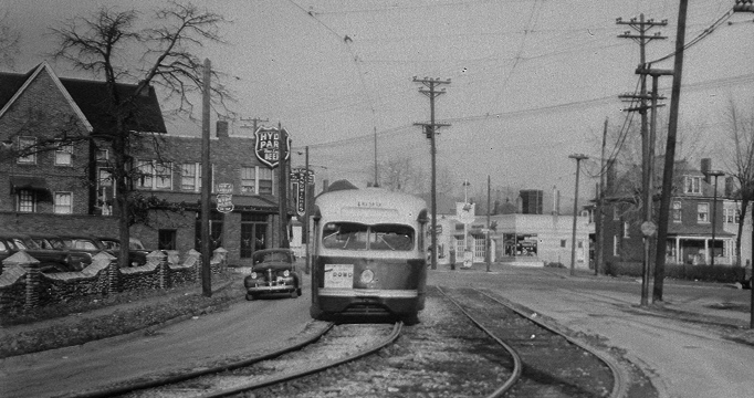
So where did all of this limestone come from? Well, here is the source of part of the limestone in our community. This is the filled in former Big Bend Quarry. Photos in our library show that the quarry was mostly filled by the mid-1950’s. The top of this photo is east. Big Bend Blvd can be seen at the top. South is to the right. The quarry was located in this corner between the railroad tracks and the old Laclede Station Road (no longer exists). Now the MetroLink tracks skirt the westernmost edge of the quarry immediately after they head south from Sunnen Station. Courtesy of the Maplewood Public Library.So how did the stone get from the quarry to the building site? Same way it does now – trucks. This advertisement is from the Post-Dispatch archives, August the 29, 1917. Sometime earlier the stone would have been transported with horses or mules and wagons.These beautiful stone walls border our Early Childhood Center (ECC) on the northern and eastern sides.Directly across Oakland from the ECC one will find this wall and gate of a very high quality of ashlar.The stonework in the two previous photos can be found in this photo probably taken in the early 1950’s. The walls once surrounded Valley School. The name is a shortened version of the original – Bartold Valley School. Bartold Valley may have been the location of an early post office. The valley itself is at the intersection of Hanley and Manchester. Bartold’s Grove, a popular resort in the mid 1800’s and later was where the present day Sunnen plant is located. This photo and the next one are courtesy of Millie Durban’s son whose name unfortunately I can’t locate at the moment.Valley School from a slightly different angle. The school was razed probably not long after these photos were taken. The new Valley school was built where the ECC is now. The oldest parts of the ECC are that school. It was still called Valley when my son attended in the late 1970’s. An apartment complex which still exists was built on the site of the Valley school in the photo.These very attractive stone columns, walls and steps are on the western side of the ECC property.Most Maplewoodians are familiar with and appreciate this stone wall that is on Flora just west of Big Bend. The wall is rubble, of course. The thin flat stones used for the top of the wall (called coping) and in the squat columns I have heard referred to as flagstones. The walls surrounding the ECC on the north and east are also flagstones laid flat over rubble.Another view of this landmark wall of ours. These should belong to the citizens of Maplewood. The owners of any of these landmarks are just temporary. The landmarks be they of stone or wood must be protected. What would our community be without them? (Don’t you get it Sierra Club?)In this photo which I found on a Facebook page called Vintage St. Louis, a streetcar passes in front of a restaurant and bar called Ted’s Corner. The beginning of the wall in the previous two photos can be seen at the left. Right behind the streetcar and across Big Bend can be seen the Parison Bakery building which now houses our friends at Frame of Mind picture framing shop. Thanks very much to the steward of the Vintage St. Louis FB page. I’d love to get a hi res version of this photo but got no answer when I inquired as to the location of the original.This photo was clearly taken at the same time as the one prior but it came from Dan Walper at Citizen’s National Bank who very generously allowed me to copy all of their historic photos. Here the wall can clearly be seen bordering Ted’s parking lot. The filling station that became Claude’s Auto Repair can be seen to the right of the streetcar. The house still exists as well. (I have been corrected by keener observers than I. This home does not exist. Most likely it was removed to increase the size of the business’ lot). I have no dates on these last two photos. The two cars that are the most visible look to be very late 1930’s or possibly from the 1940’s. From memory automobiles were produced I know in 1940 but stopped shortly after that due to WWII. Auto production didn’t resume until 46 or 7. (Look it up. I can’t do everything.) The streetcars stopped running on this line in 1949. The photos are earlier than that is all I can say. It is possible that these photos were taken because the line was going to cease running in a very short time. I have a couple more posts of stonework coming so be patient if you haven’t seen your favorite yet.
25 COMMENTS
The pic of the stone walls that surrounded Valley school could have been donated by Robert Durban, M-RH class of ’62.
In general, I always try to attribute the photos or information to the folks or institutions from which I received them. It is a nice thing for them to do and I appreciate it. If it was indeed Robert Durban, I thank him and apologize for not finding my notes on this. Thank you, Sandra, for providing his name.
Thanks for this fascinating article! I’m trying to figure out where the quarry was, would it be where some of Sunnen is now? Or Deer Creek Center? My uncle once told me it was where the Family Video is now but I’m thinking it must have been a bit north of there.
I live near Big Bend and Manchester and I’m guessing our home’s stone and mortar foundation was built with this limestone!
Hi Annie, the Big Bend Quarry was located just north of the railroad tracks and immediately east of the MetroLink tracks. The building in the SW corner of the Sunnen Business Park is located directly over the filled in quarry. The stones in your foundation may well have come from this quarry. As far as I know there is no way to know for certain. Thank you very much for your comment.
Thanks for clarifying th quarry location!
My pleasure. Stay tuned for an upcoming post on the quarry.
The two streetcar pictures were taken in February 1949 and the photographer was Ray Gehl. The car in the second picture is a 1940 Chevy coupe. There were three streetcar lines that left the Maplewood Sutton loop, one #54 Manchester-Webster Groves, the second was #55 Manchester-Kirkwood(Clay and Adams) , and the third was #56 Manchester-Kirkwood (Woodbine and Magnolia). The Manchester line closed on April 2 1949. These lines used the old Edgebrook trestle to get over a ravine, Deer creek, and the Missouri Pacific main lines to get into Webster and Kirkwood. I got this info from three St Louis streetcar books by Andrew D Young. There was also a #53 Manchester-Maplewood line that started downtown and ended at the Maplewood Sutton loop. I believed all Manchester lines started in downtown. I hope this info helps.
It does, NW Berra. I will copy and paste this info into my streetcar file. Much thanks for sharing your research.
I was in Deer Creek Park last weekend with my three year old daughter when an older gentlemen passerby told me for the first time about the old streetcar bridge (“the old Edgebrook trestle” I presume) that came down that big hill off Dutton Ave. He couldn’t reconcile in his mind how it got across Deere Creek and the train tracks.
I feel like I should be able to spy it in your aerial photo of the quarry, but I can’t seem to make it out. I believe I’ve seen a higher resolution version of that photo before as I took an interest to it since I used to work in that industrial court which now stands there. I would love to learn more about this (and pretty much any of the material in this awesome topic you’ve just started for which you now have me eagerly awaiting to see the next chapter).
Thanks!
Jim, thanks for your comment. I have photos of the Edgebrook bridge which I will post hopefully before too much time passes.
these pictures are awesome I remember top picture of trash dump/sefton fields ballfield/ Can Corporation where they made comet cleaner cans and the other side was Mississippi valley steel still remember that. Thank for all the pictures
You are welcome, John. I’ve got more coming that you will like. Thanks for your memories.
I am surprised that many people apparently believe that the Sierra Club is supposed to save everything that needs saving, including buildings. I am no friend of the Sierra Club but they have never defined their mission as anything more than protecting the natural world. Are they responsible for everything? If they tried to do that they would be false to their mission and ineffective as a result.
Preserving historic buildings on the national level is the mission of the National Trust for Historic Preservation. On a state level the Missouri Department of Natural Resources is responsible for the preservation of historic buildings and sites. The Missouri Alliance for Historic Preservation is another state-level organization that works for Historic Preservation of buildings and historic sites. They are currently working to achieve full and permanent Federal funding for the Historic Preservation Fund. You can help them at http://preservemo.org/.
Hi Bill, In response to your first sentence I’d like to say that I don’t know anyone including myself who thinks “the Sierra Club is supposed to save everything that needs saving, including buildings”. You say you’re no friend of the SC. I have been a member in the past and would like to be again but at present I can’t support local leadership that makes decisions as dumb as gutting our historic Harper’s Pharmacy.
Your first sentence in your second paragraph is a bit misleading. The National Trust for Historic Preservation (of which I am a member having first enrolled in the 1970’s) “helps people protect, enhance and enjoy the places that matter”. They also maintain the National Register of Historic Places which is used to decide who gets historic tax credits. We have many buildings in Maplewood that are listed on the National Register but guess what. If someone wants to demolish one of those buildings or significantly alter it there is nothing the National Trust can do. Ditto for the Missouri Alliance for Historic Preservation (now known as Missouri Preservation of which I am also a member). The only restriction that results from a building being listed on the National Register is that federal funds cannot be used to demolish it and that ain’t much. I occasionally talk to folks who believe these historic buildings have some sort of legal protection but they usually don’t. Only places such as Soulard or Lafayette Square whose property owners agree to a very tough historic code offer their buildings some protection.
As for the local chapter of the Sierra Club, just because their leadership has done something stupid doesn’t mean they can’t rectify it. They should restore and return as many of those historic cabinets to their original positions as they can. I think they’d be overwhelmed by the positive response.
The more I thought about my answer here the more I thought it just can’t be correct. A call to Esley Hamilton confirmed that I’m right, it’s not. The National Trust is a nonprofit and therefore wouldn’t be handling federal money. The historic tax credits and the National Register are handled by the National Parks Service which is under the jurisdiction of the Secretary of the Interior. Sorry about that.
Doug, what a fabulous telling of our Maplewood history in stone!
Thank you for the SO many things you keep up with and share with us!
Melemai, You are welcome and thanks so much for taking the time to express your appreciation. It means a lot.
I enjoy this topic and your pictures/information. Sherman Shoemaker is an expert on Limestone. I had the privilege of traveling with Lynne and Sherman to Indiana and seeing a number of beautiful homes and a quarry of Limestone. That state has provided stones for New York city and other states important buildings. But loved hearing some of St. Louis’s stone stories.
Hey Nora, Sherman has been a consultant in the past regarding my stone questions. If he knows the name of this visible white limestone that is everywhere I’d like to hear it. I have no memory of it if I ever knew it. The Indiana limestone you mention is known as just that. It is a gray featureless stone that has been used in many government buildings including our post office. Our St. Louis limestone (I’m calling it that anyway) is much prettier. It is good to hear from you. Thanks for chiming in.
@Doug – In an old post of yours about Bartold’s Grove on the Patch, there is a picture of the building with some nice stone walls running alongside. I know Sunnen itself has some stone retaining walls. Re-purposed maybe?
The building to which you refer was known as Bartold’s Inn. It disappeared in the late 1950’s or early 1960’s, if I remember correctly. You asked if any of the stones had been reused into the stone walls seen at that location today. I don’t know. I would guess that they might have been. But if the demolition had occurred in recent years I would say the original stones probably had not been used. The common method of demolition today is to scoop up everything, load it in a truck and haul it off to a landfill. Were they doing it this way back then? Can’t say. The problem with reusing the stones is they usually have paint, tar or some other unattractive substance stuck to them.
I agree with DSmith. The brick home in the last picture is gone now, and is just a parking lot for the repair shop.
@Doug – That building that Ted’s was in was big! It’s sad that the stretch of Big Bend from Flora to Comfort is completely empty when there were such nice buildings previously. Was it solely to widen the road you think?
Ian, you are absolutely correct as well about the brick house in the last photo being gone. I agree it was sad to lose a building like Ted’s and others that we don’t know about. I believe it was due to the widening of Big Bend but can’t say so with absolute certainty. Also I have been asked what is the building just north of Ted’s with the large roof? I don’t know. I remember seeing it from another angle in a very poor photo which I’ll try and locate.
Doug, In the bottom photo, the house that you mention is still there, looks too close to the corner to be there now. Also, it looks like a brick house. A similar or same house that is near that corner now, is a frame house. Thoughts?
Mr. Smith, you are absolutely right about the first part and probably right about the second part too. I have in my mind that the house closest to Claude’s is a brick house similar to the one visible in the last photo. I haven’t driven by to check yet but I will. It is always good to hear from you. Thanks for pointing this out. I’ve made a correction in the text.
Comments are closed.