
The title of this post should probably be Let’s Go Get Stones since it is about the Big Bend Quarry, the origin of many of Maplewood’s building stones. A number of readers expressed interest in and had questions about the BB Quarry. Hopefully this post will be of interest to the rest of you as well. If the text below seems familiar that’s probably because I posted it almost exactly two years ago.
The Big Bend Quarry
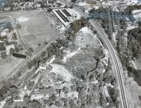
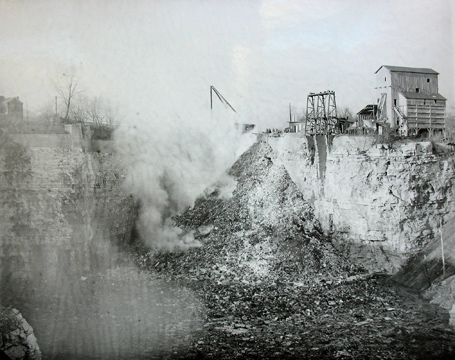
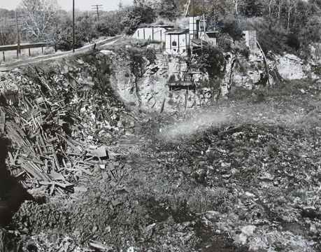
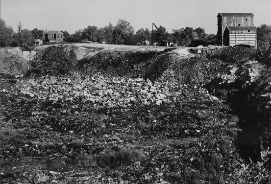
For many years a quarry of a substantial size operated in Maplewood. Known as the Big Bend Quarry, it is not identified on the 1909 Plat Map of St. Louis County nor is it found in the 1912 Directory of the City of Maplewood. It was in business by 1917 according to an advertisement found in the archives of the St. Louis Post-Dispatch.
The retired firefighter, Dewey Eberhardt, once told me that it was hundreds of feet deep with tunnels that went off in several different directions. I’m guessing that the quarry’s main products were limestone for buildings and crushed limestone for roadbeds and concrete, etc.
The quarry was located just south of the present day Sunnen Metrolink station. It was east of Laclede Station Road and north of and as close to the railroad tracks as possible. This was probably to facilitate the shipping of the stone.
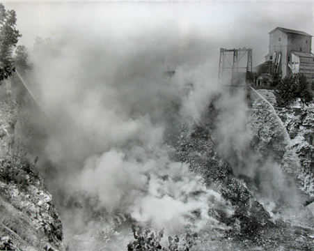
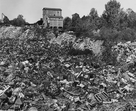
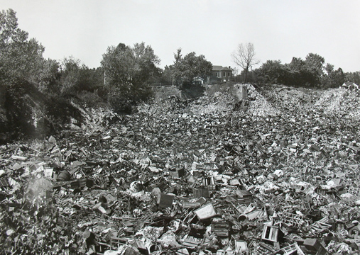
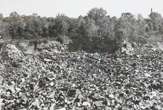
Once the removal of stone had ceased for whatever reason, the quarry became a waste disposal site. According to Dewey, Mallinckrodt Chemical amongst many others sent railroad cars to be dumped into the quarry.
One would suspect a witches brew lurks somewhere in the depths below. I’d feel better if I knew that the local office of the Environmental Protection Agency was aware of this site and others like it of which there must be many. I’d really feel better if I knew that they monitor and test these sites regularly to make sure whatever was once put down there stays down there.
Doug,
Extremely interesting article,,, I guess you know I’ve been around just about as long as some of the dust here… I remember the old woods in the rear of Sunnen ( Bum’s Jungle) The Creek that was the site of several kids’ demise. (Sefton Can company, Sefton fields, (used to play baseball there), and Mississippi Valley Steel,, ( their latest built offices are still there on Big Bend-MC Industrial- only the small front building was from the late 70’s,, you can still make out the change in contours of the hill behind it that led to the original factory.) When the overpass on Big Bend was built and your house and the one I grew up in lost our entire front yards. The original gas station turned car lot ( Rickman’s) where the old QT is now. The Texaco where the parking lot for MC Industrial is now.. The Train shop where the frame shop is now.. The Masonic Lodge at Big Bend and Manchester, They left, never to return, Roper Dan’s Ford; became Cavalier Ford; The Theatre at James and Sutton ( Outdoor Theatre),,The Moose Lodge on Sutton, Left, Never to return; Paul’s Tavern where the Yoga place is on Sutton. Eli’s confectionary on Sutton between Elm and Flora.
Dedication of the new “Bible Baptist Church” on Sutton. The Italian restaurant where the parking lot across from Claude’s is now. ( Dattoli’s I believe). The reason Behind the name of Martini Drive Not a drink)…The picture of JFK crossing the tracks at Greenwood and headed north on Sutton in a convertible. Any have comments or filler on any or these or others …Doug?
Hi Bill, it’s good to hear from you. You cover a lot of territory with your comments. I won’t try to address all of them. Many have been covered in previous blog posts, 113 of which can be found at this site. Another 100 or so were posted on the former Maplewood/Brentwood Patch web site. You may have luck finding some of those by searching for the subject. Prior to that I supplied historic photos for the City of Maplewood’s Facebook page for 2 years. Masonic Hall covered. Moose Lodge covered. Powhatan Theater covered. I’ve posted an aerial photo of Big Bend and Greenwood before the viaduct was built. Also posted an image of a painting made of the same intersection and a photo of my house before the front yard was removed. I have no memories or photos of the Italian restaurant you mention. Martini was a mayor. I’ll offer just one correction: Paul’s Maple Leaf Tavern is now a photography studio. The building once housed the indoor part of the Powhatan Theater. I published the picture of JFK crossing the tracks at Sutton in the book I put together for Maplewood’s centennial. I think it was also shown on the city’s Facebook page. Other than those two places I don’t believe it was ever shown publicly. So I’m curious. Had you seen that photo prior to the book coming out in May 2008? If so where? Much thanks for your many interesting memories.
Yes, That photo has been floating around for a few years, I remember seeing it as a kid on the wall at what is now ‘Foley’s” ( I can’t remember what is was back when dad dragged us kids there) but that’s I was familiar with it, and as I got older I thought about and dug it up on the internet. The photo of JFK is also on a face book page of M-RH alumni that I posted,,,
several people remember the “parade” going up Sutton.
Thanks for your other comments, I am so sad about My old house,, but in My parents waning years there was noting more they could do. I will scour some of their relics for anything also on the area.
Any updates since you originally posted this regarding EPA testing? What, exactly, is on the dumping site currently? Sunnen? The ECC???
Beth, I know the southwestern most building of Sunnen’s is built on top of it. I don’t know if the one next to it is or not. Thankfully the ECC is a good distance away from this site. I’ve been told that the Sunnen buildings were built to protect the inhabitants should any vapors migrate upward. Apparently there is a collection system installed beneath them that will allow vapors to be vented away from humans. The Sunnen Corporation and subsidiaries have a record of being very responsible members of the community. Our fire chief, Terry Merrell and I have discussed this a couple of times. Recently he told me that he thought the site was tested for radiation prior to Sunnen’s buildings being constructed. He said only a very low level radiation was found deep down that would not pass through (I hope I’m remembering this correctly) a sheet of paper. Call him if you like. I’m sure he’d be glad to explain. I feel reassured by these facts. I live directly across Big Bend from this site. Same very porous house for 40 years. So far no problems and none that I know of amongst other long term neighbors.
Still I’d be curious to learn from the EPA if they monitor these sites at all. If you or anyone else learn any new info I’d be glad to post it.
Thanks for the detailed reply! Love this source of local news- keep up the good work!
It is my pleasure, Beth. Will do.
Hi Doug – when I was researching for my book Kennedy Music, I read several ads in the County Observer for employees at Sefton Can Co. In the late 1930’s – 40’s the pay was like 45 cents an hour, and that was apparently a desirable wage.
That’s very interesting, Wanda. Thanks for that detail.
Comments are closed.