As one might expect after after many years of looking at historic images of our community I’ve become familiar with many of the names of families and businesses that once populated our town. Many of their names occur over and over through out the decades.
Chronologically the largest property owners would begin with Gratiot who appeared sometime in the late 1700’s. James Sutton arrived in 1826 and Charles Rannells came on the scene in 1848.
Sutton and Rannells both died in 1877. Sutton’s property was divided amongst his children into portions some of which we easily recognize today. John seems to have inherited the mansion once located where Dobb’s Tire is today. Sarah built a home that is now part of J.B.Smith Funeral Parlor. Kay or Kate (she appears in the historic record both ways) built a home that still exists on Roseland Terrace. Mary had a home on the SE quadrant of Sutton and Manchester.
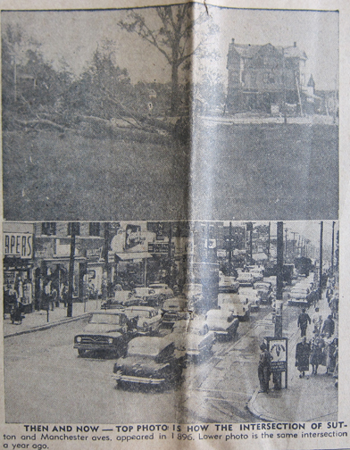
These Sutton homes are each located on one of the quadrants of the aforementioned intersection. I have photographs of all of them. I mention this because sometime ago I found a photo in a St. Louis County Observer newspaper on file at the Maplewood Public Library that baffled me. I’ve reproduced it below.
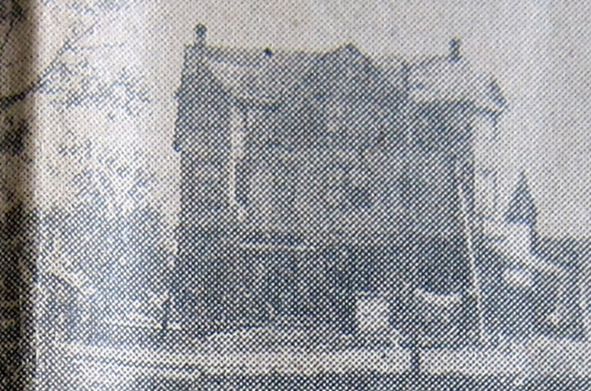
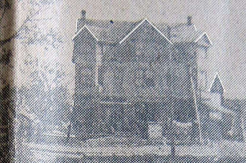
The photographs are from the September 10, 1958 issue of the Observer. It was a special issue celebrating the 50th anniversary of our town. The view in the bottom photo is looking east down Manchester from Sutton. The building in the top photo blew my mind.The image quality is poor due to its being a newspaper photo. As you can see, the image is of what looks to be a three story frame building. Three stories! And very large. 1896 is the year the streetcars began operating. There are not many structures here today that were here then. If this building were some person’s house they would have to be very rich. The Suttons had owned everything not long before this photo was taken. I believe in the early 1880’s there were only four homes on what was once the whole Sutton farm. If this building belonged to a business almost certainly I would have run into mention of it or a business large enough to support it.And what a weird building it is. I’ve added lines to highlight what looks to me like five gables on the main structure and possibly one on a smaller building in the rear. What could this building possibly have been for? It reminds me of some of the rambling shingle style structures that are seen in the east around horse racetracks. One possible reason I may not have heard of it is that it may have had a very short life most likely due to fire or business failure. Whatever the facts are concerning it they are so far lost in time.
7 COMMENTS
Perhaps the newspaper made an error and pulled a photo for the “then” that did not relate to the “now” photo below-if they pulled the wrong photo or it was mislabeled and someone else noticed the error, maybe there is a correction made in the next couple of editions of the newspaper. Look for corrections. Big structures like that do not just remain a mystery, land maps were pretty accurate by that date.
I have to think Pat is probably on to something. As I have indicated I have quite a bit of information about the history of the intersection where this building is supposed to have been located. None of it even alludes to a building like this having been there. Maplewood in 1896 was little more than a rural suburb with some nice homes, of course, but the business district was pretty basic. The 1909 map shows a lumberyard located on part of what is now the Shop’N’Save property with another one on the SW corner of Manchester and Sutton. This three-story building is out of scale as well. I’m fairly certain all of the other known buildings at the time were one and two-story. We know where to look for the answer, the newspaper archives. Looking for the correction Pat mentions would be a start. I hope someday this mystery will be solved. Thanks to everyone who commented.
The right side looks like it could be the building where Orbit now is located. The shadows in this photo make it seem that the building front is facing south.
Doug, Those trees on the left of the photo appear to be blown down, not pushed down, and there may be a church steeple in the background of the right side.
Good points, Gary. I wonder how they would have removed trees in 1896. I don’t think they had any bulldozers. This photo might be of the aftermath of a storm. There were several frame churches in the area that could conceivably have belonged to the steeple in the photo if it is one. The church at Hazel and Sutton still exists minus the pointed roof that its steeple once had. There was another at Sutton and Flora which burned and was replaced by the current Methodist church building. And the original Baptist church at Marietta and Marshall was frame and similar to the others.
I do too, Gary. This one is truly a riddle. I wonder just what quadrant of the intersection this building might have been located in. I think we’d have to rule out the NW quadrant because it was still occupied by the Sutton mansion and outbuildings in 1896 and as late as 1909. The SW quadrant slopes away from the intersection. Is the layout of the land doing that in this photo? I don’t think so. The SE quadrant owned by Mary and Merritt Marshall also slopes away from the intersection. The photo we have of the Marshall home is of a straight forward, rectangular, two-story farmhouse. Perhaps this was later razed and this large building was built on the site? I doubt it. The Marshall home appears to me to still exist on the 1909 map. The 1909 map shows the footprints of the buildings. I have found these to be very accurate in depicting the shapes of the buildings disregarding the porches. I’ve not found a footprint on the 1909 map that is the shape of this unusual building, a rectangle with a center projecting wing flanked by two wings that appear to be at 45 degree angles to the main part of the house. Weird. That leaves the NE quadrant. Sutton heads up a substantial hill just north of Manchester. The hill was undoubtedly cut away some for the first generation of buildings along Manchester and then excavated dramatically in the 1970’s for the K Mart fiasco. Point is most of the hill existed until the 1970’s. Is it in the photo? Doesn’t appear to be. I’m stumped.

Perhaps the newspaper made an error and pulled a photo for the “then” that did not relate to the “now” photo below-if they pulled the wrong photo or it was mislabeled and someone else noticed the error, maybe there is a correction made in the next couple of editions of the newspaper. Look for corrections. Big structures like that do not just remain a mystery, land maps were pretty accurate by that date.
I have to think Pat is probably on to something. As I have indicated I have quite a bit of information about the history of the intersection where this building is supposed to have been located. None of it even alludes to a building like this having been there. Maplewood in 1896 was little more than a rural suburb with some nice homes, of course, but the business district was pretty basic. The 1909 map shows a lumberyard located on part of what is now the Shop’N’Save property with another one on the SW corner of Manchester and Sutton. This three-story building is out of scale as well. I’m fairly certain all of the other known buildings at the time were one and two-story. We know where to look for the answer, the newspaper archives. Looking for the correction Pat mentions would be a start. I hope someday this mystery will be solved. Thanks to everyone who commented.
The right side looks like it could be the building where Orbit now is located. The shadows in this photo make it seem that the building front is facing south.
Doug, Those trees on the left of the photo appear to be blown down, not pushed down, and there may be a church steeple in the background of the right side.
Good points, Gary. I wonder how they would have removed trees in 1896. I don’t think they had any bulldozers. This photo might be of the aftermath of a storm. There were several frame churches in the area that could conceivably have belonged to the steeple in the photo if it is one. The church at Hazel and Sutton still exists minus the pointed roof that its steeple once had. There was another at Sutton and Flora which burned and was replaced by the current Methodist church building. And the original Baptist church at Marietta and Marshall was frame and similar to the others.
I sure hope someone will come up with the answer. Too much history has been lost.
I do too, Gary. This one is truly a riddle. I wonder just what quadrant of the intersection this building might have been located in. I think we’d have to rule out the NW quadrant because it was still occupied by the Sutton mansion and outbuildings in 1896 and as late as 1909. The SW quadrant slopes away from the intersection. Is the layout of the land doing that in this photo? I don’t think so. The SE quadrant owned by Mary and Merritt Marshall also slopes away from the intersection. The photo we have of the Marshall home is of a straight forward, rectangular, two-story farmhouse. Perhaps this was later razed and this large building was built on the site? I doubt it. The Marshall home appears to me to still exist on the 1909 map. The 1909 map shows the footprints of the buildings. I have found these to be very accurate in depicting the shapes of the buildings disregarding the porches. I’ve not found a footprint on the 1909 map that is the shape of this unusual building, a rectangle with a center projecting wing flanked by two wings that appear to be at 45 degree angles to the main part of the house. Weird. That leaves the NE quadrant. Sutton heads up a substantial hill just north of Manchester. The hill was undoubtedly cut away some for the first generation of buildings along Manchester and then excavated dramatically in the 1970’s for the K Mart fiasco. Point is most of the hill existed until the 1970’s. Is it in the photo? Doesn’t appear to be. I’m stumped.