Perhaps this post should be titled something like Just Over the Border of Maplewood… History. I think the intersection of Manchester and McCausland is where the Maplewood business district truly begins. No matter that it is a block east of our actual border. It was either within the survey of the farm of our pioneer settler, James Sutton, or right on the edge of it.
This image I discovered while looking through the posts by Joe Sonderman on his Facebook page, Vintage St. Louis and Route 66. It is a fascinating collection that he has assembled. This is not the first time I’ve found an historic image related to Maplewood there.
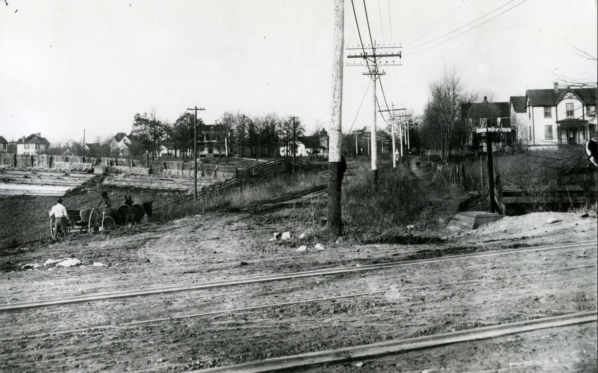
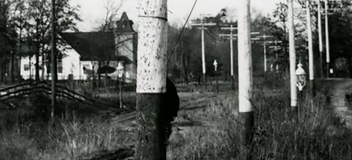
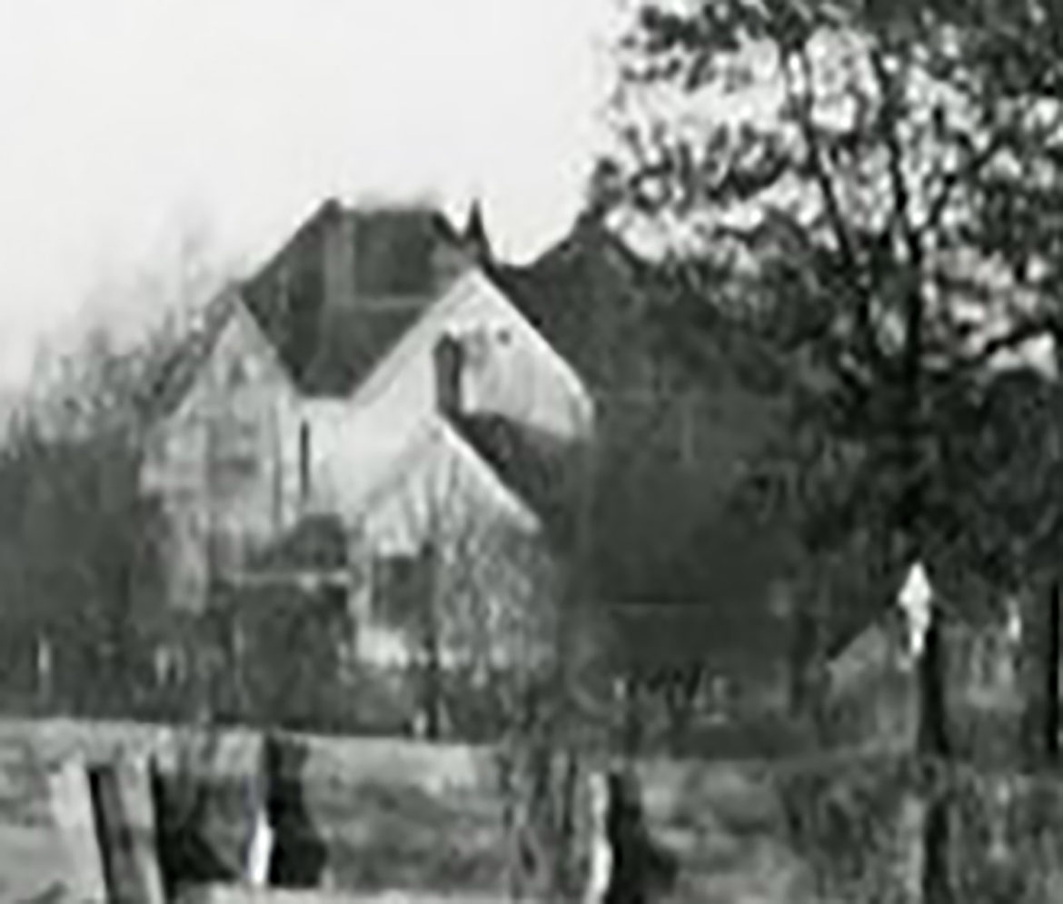
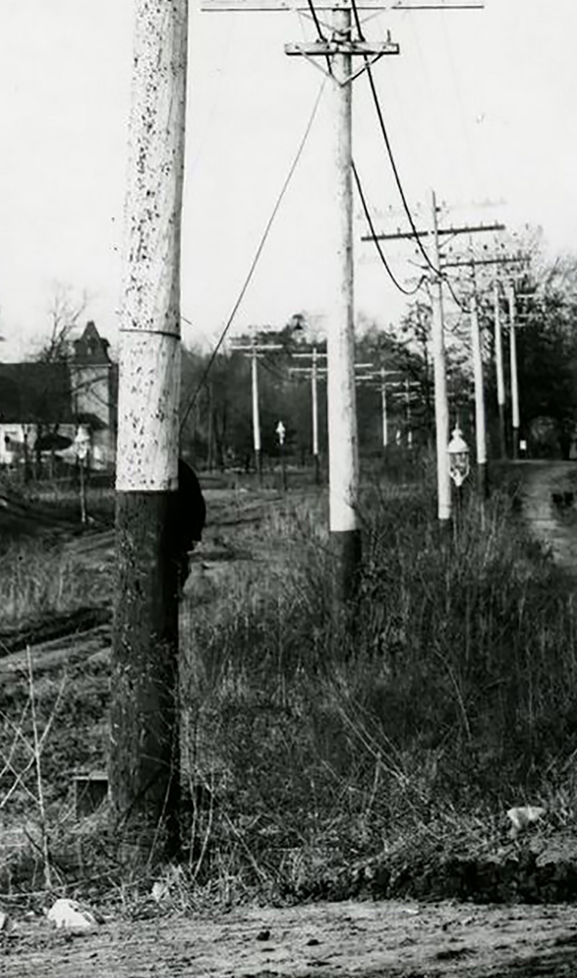
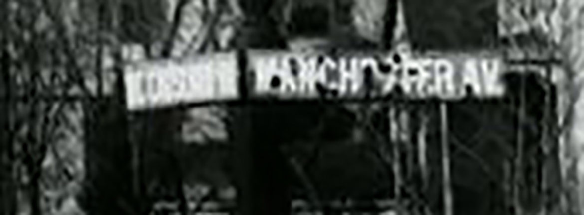
This particular image stopped me in my tracks. I thought this could not possibly be the intersection of Manchester and McCausland. But it is. There are even street signs on the corner. Just look at McCausland. It looks like nothing more than a dirt track through a farmer’s field and yet it has streetlights! On the Facebook page, readers commented that most of the buildings are still there. I had to go and see for myself. Guess what? They are.
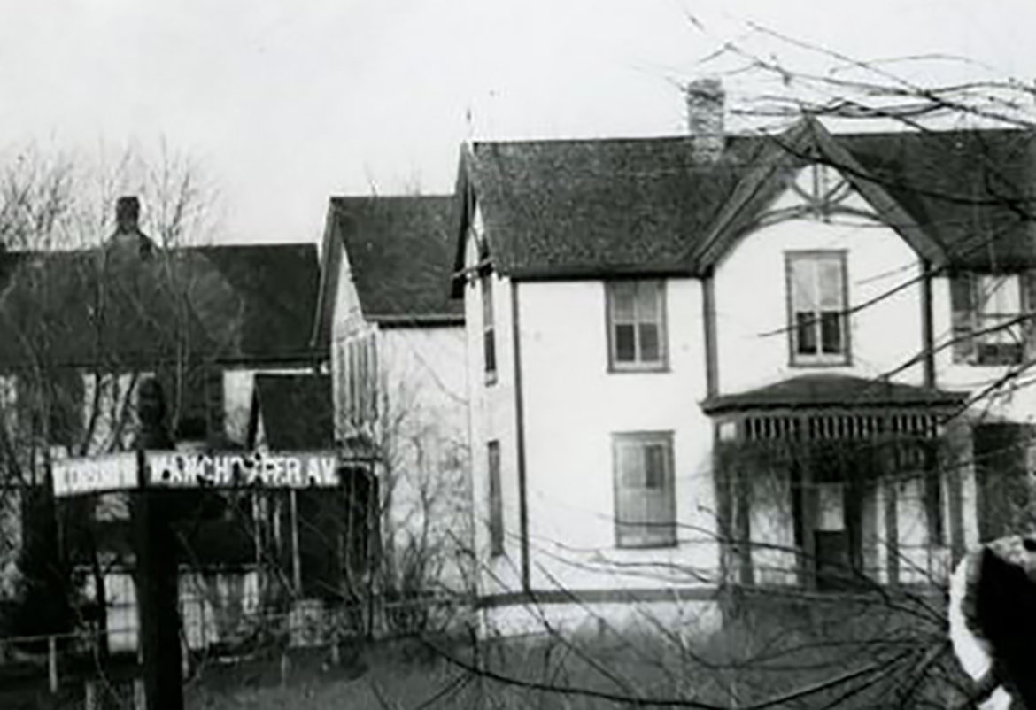
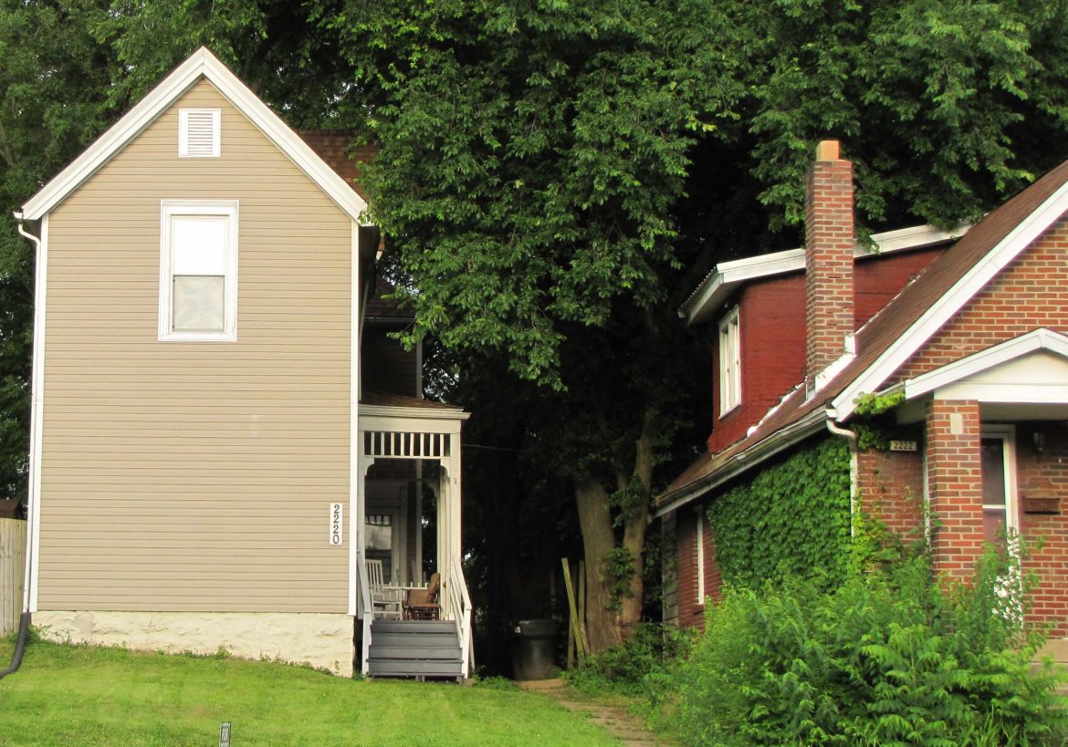
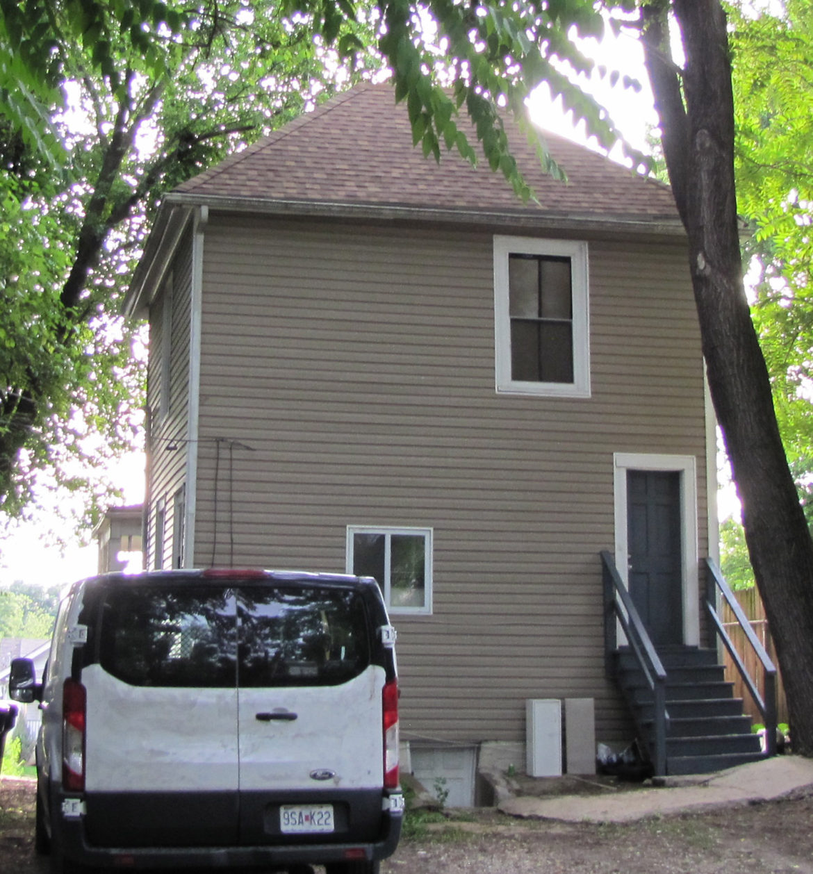
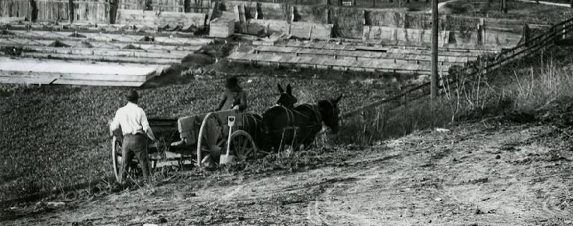
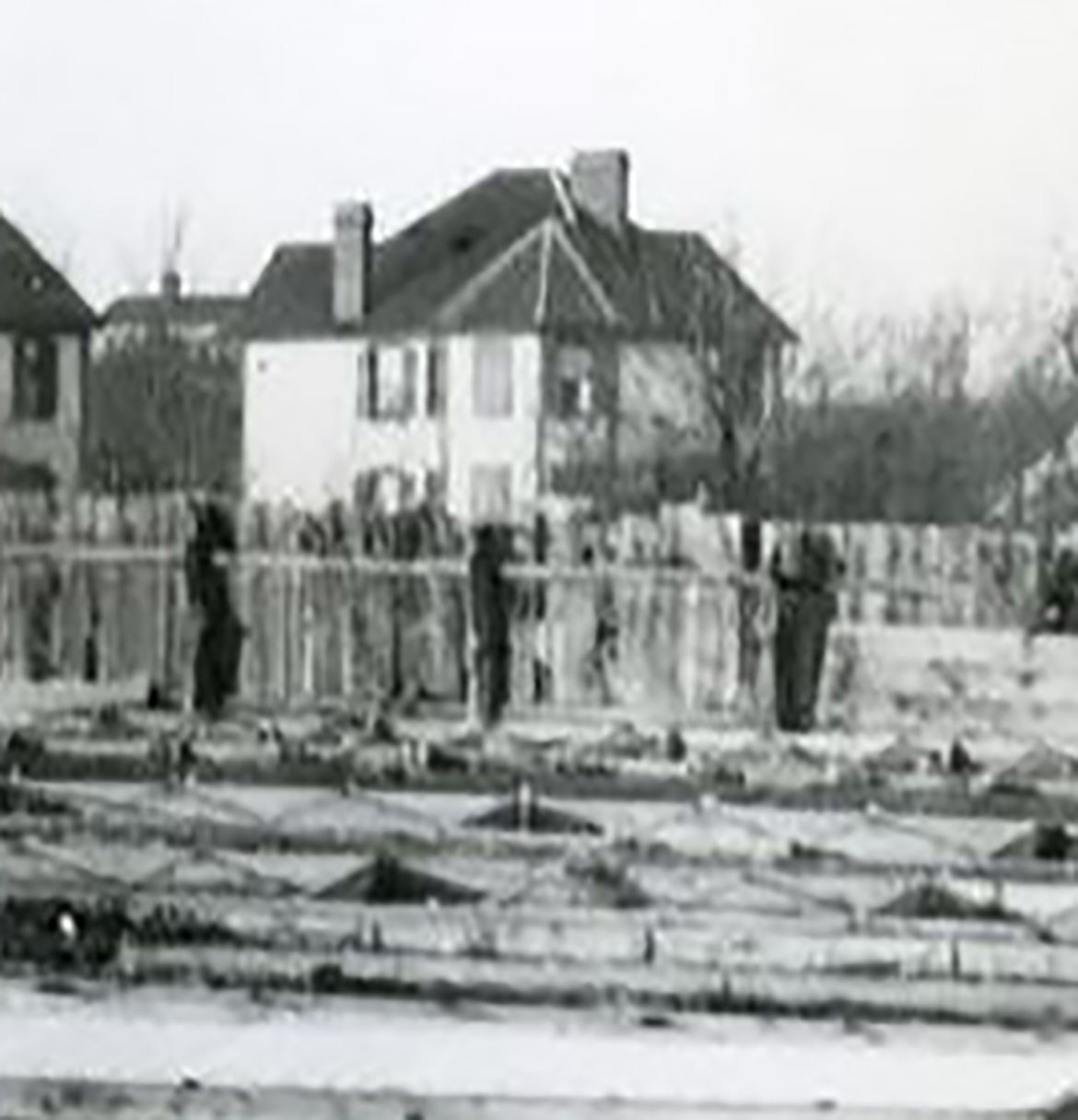
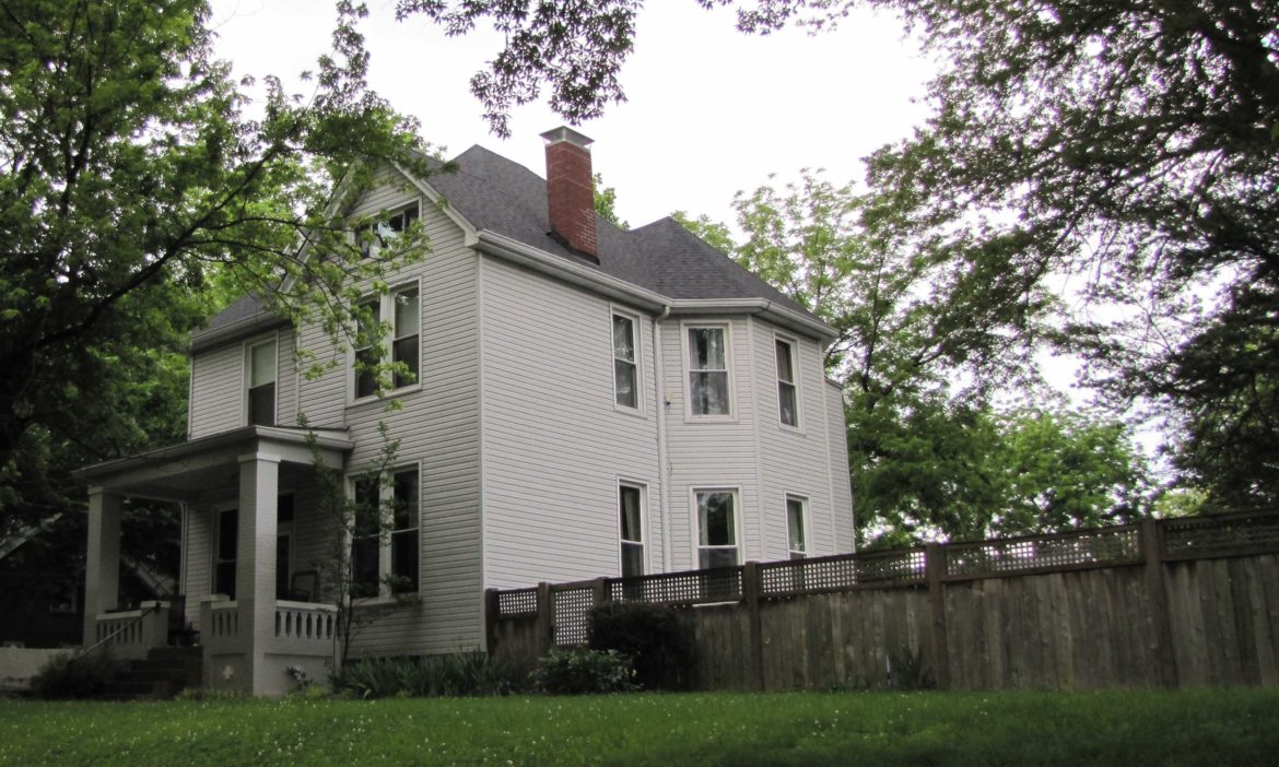
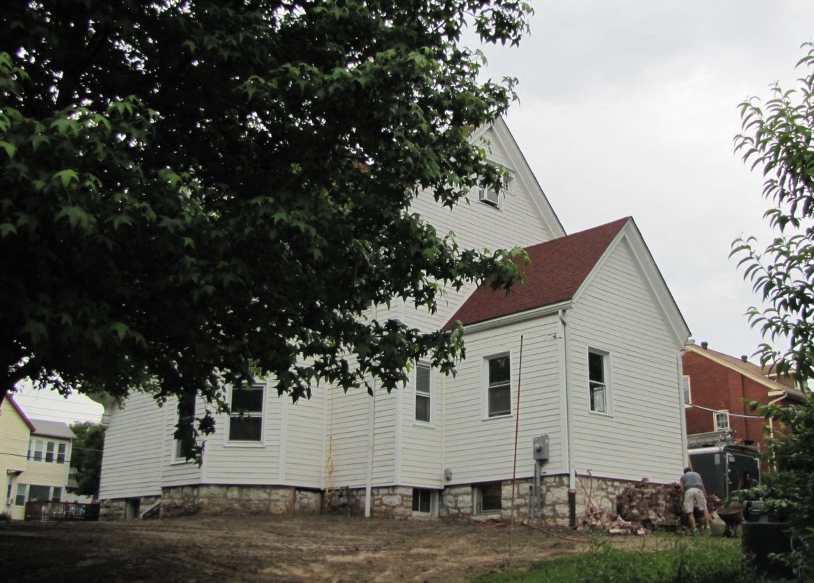
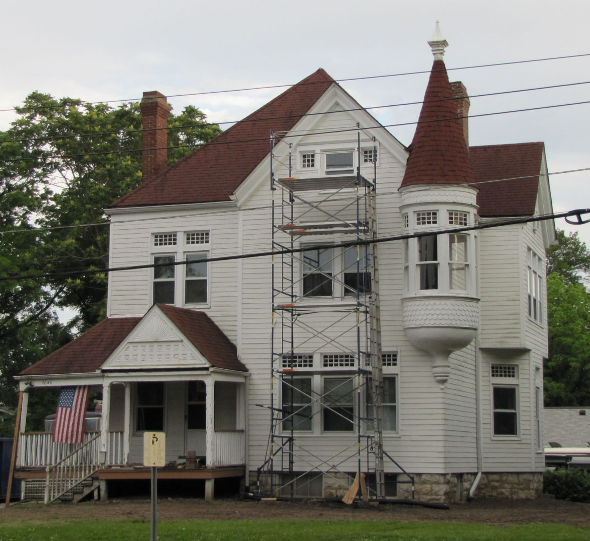
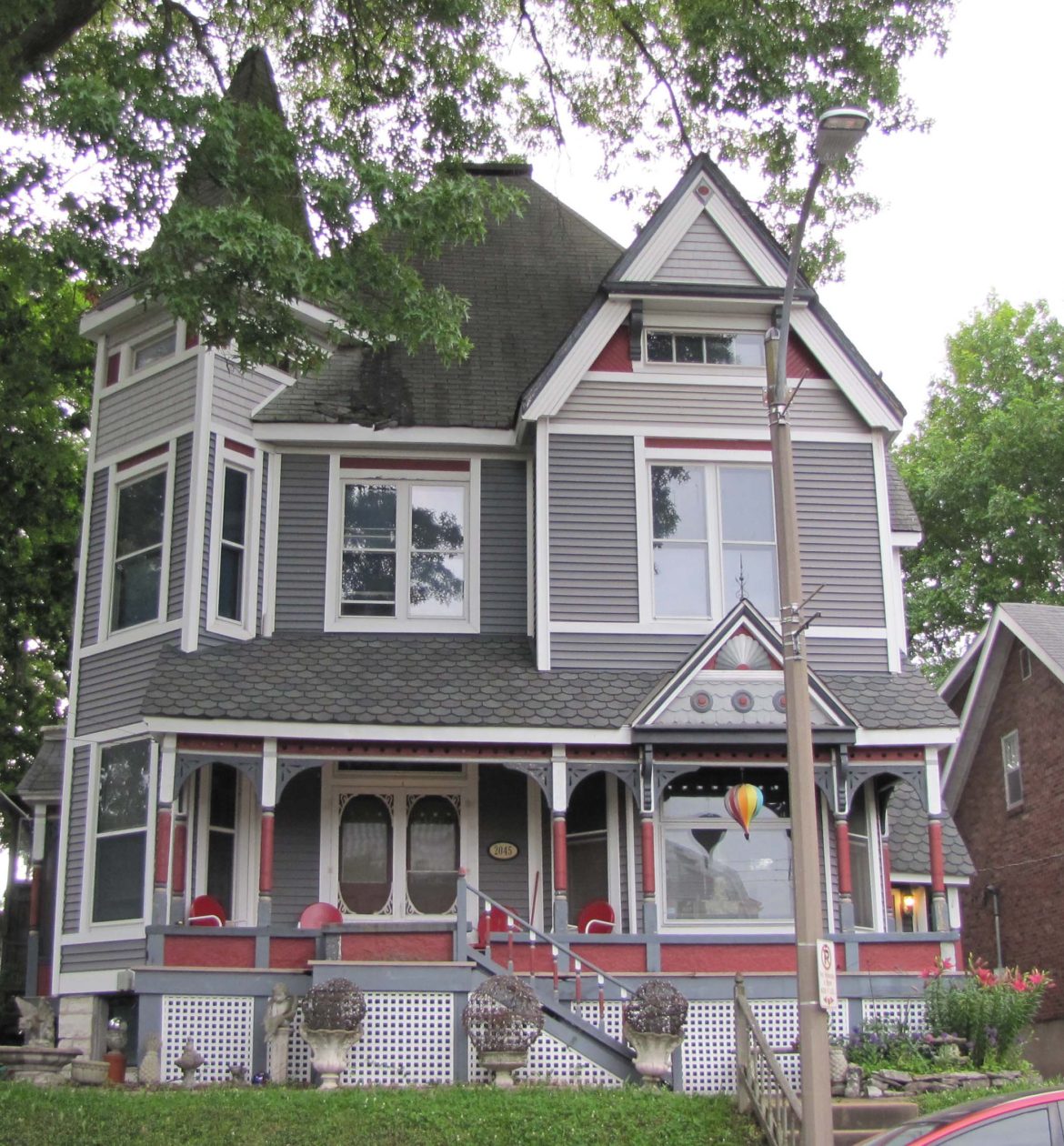
When I first began to try and decipher this image, I supposed from the condition of the roads that it must have been taken around 1900 before the advent of the automobiles. A little research proved that supposition wrong.According to Zillow or one of those Zillow-like websites, these two homes were built in 1913. There were many automobiles around by then. Production of the well known Ford Model T began in 1908. Today the address of the home in the foreground is 2220 McCausland. The one directly behind it is at 2214. When the first home was built it faced Manchester. Then later the front yard was developed and the address was changed to McCausland. Note the 2 over 2 windows. Meaning 2 panes of glass in the top sash and 2 panes in the bottom sash as well. One of the great features of this amazing image is the inclusion of the street signs. They leave no doubt about the location.The western elevation of the home in the foreground now at 2220 McCausland. It lost a window and gained several buildings in the front yard. One home is visible. Remember the 2 over 2 windows? Gone. It also lost some interesting gingerbread in the front and side gables.Looking at the eastern elevation we can see that the building has been remodeled. It doesn’t appear to have the front gable any longer but look at that upstairs window. 2 panes over 2 panes.And streetlights. The shortest ones I’ve ever seen. In what amounts to out-in-the-country along a dirt lane. It truly makes me wonder. There is a church at approximately this location today but it is a different building.And what about these two fellows with the mules? Just what are they up to? And what is going on in the background?Judging from the chimney, the windows below and behind it and the roof over the bay windows, this home on the far left of the original photo may be……this home on Blendon Place. It even still has the vacant lot next to it.Almost directly above the mules can be seen what appears to be a very large home. Actually it is two very large homes. One is at 7040 Stanley and the other is at 2045 Blendon Place. Closest to us is a one story addition on the rear (southern elevation) of 7040 Stanley. Directly above the chimney of this addition and a little to the right the candle snuffer roof of the tower on the front of the home can be seen.The rear addition today of the home at 7040 Stanley.The front (northern elevation) of 7040 Stanley, built in 1895. Isn’t this a beautiful home? It is currently undergoing renovation from top to bottom. In October of 1956, Pauline W. Pfeifer passed away. She had lived in this home for 50 years. She was the widow of Herman J. Pfeifer, chief engineer of the Terminal Railroad Association, who had passed in 1941.Catty corner across an intersection sits this magnificent home at 2045 Blendon Place. It was built in 1887. Part of the roof line can be seen in the original image. In 1892, a man by the name of John T. Field advertised his two carriage horses for sale. He was still here in 1902, when he offered to rent the 10 room house for $60. In 1905, it was advertised as an 11 room house and offered for sale for $15,000. In 1929 it was billed as an 8 room home and offered for rent at $50. In 1987 it was advertised as a 13 room home and put on the market for $58,900.
Perhaps the most interesting thing to me about the original photograph was the condition of the streets. I didn’t expect them to be paved but I expected them to be in much better shape than they were. The Maplewood subdivision advertised Telford streets as early as 1890. I am not certain what a Telford street is. Some sort of paving, I imagine.
Early automobiles had wheels similar ( or identical in some cases) to wagon or carriage wheels. This type of wheel was apparently necessary to travel on unpaved surfaces. I have seen images of early vehicles in massive mud holes. Try to imagine the condition of the McCausland Avenue in the image after a few days of heavy rain. A mess.
I’ll have more on the Cora Clamorgan story in upcoming posts.
Until next post, obey all of the social distancing rules. Wear your mask. Wash your hands. Wipe your feet. No shaking hands. No hugging. No kissing. Hopefully we’ll all get through this OK.
Doug Houser June 9, 2020
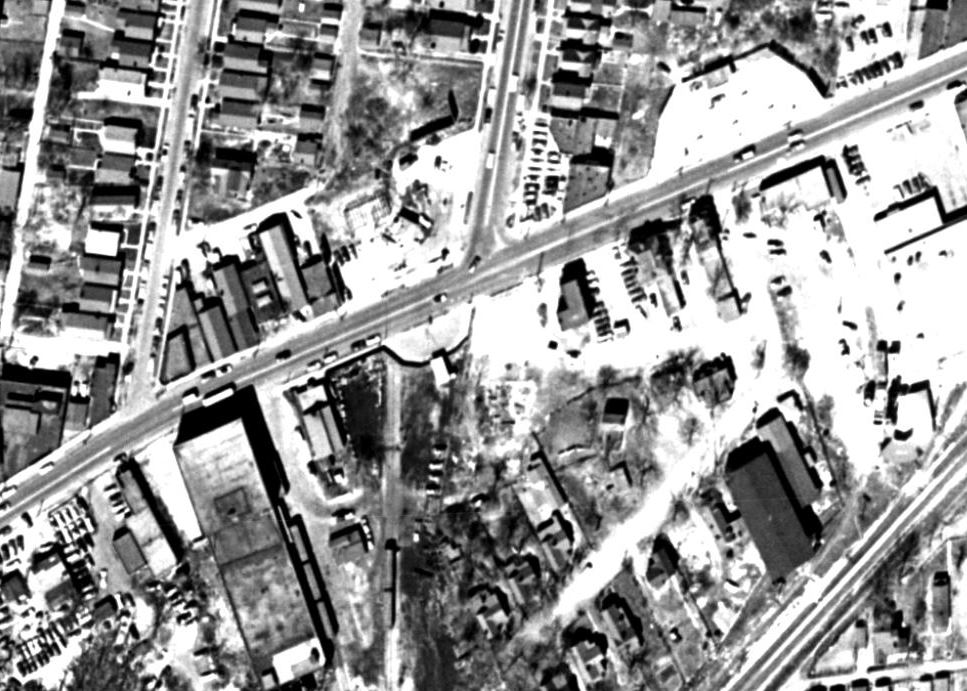
Reader Mike asks about the black blob on the first telephone pole. I can’t tell what it is but it appears to have a wire going to it. Looking at this enlarged detail, I now notice that there is a depression in the roadway made obvious by the white paint on the poles. The streetlights are not as short as they first appeared. If the white paint begins about 4 feet above the ground then the bottom of the light might be at about seven feet or so? What do you think?Reader Mike also asks if those are bullet holes in the Manchester sign? Mike, that is a really great catch especially considering you had no more than a fairly low resolution image to look at. I think you are exactly right! I got a big kick out of this. I don’t know if we can take any comfort from the fact that they had those dumb ____ around then too. Maybe we haven’t made much progress.Here is an enlargement of a home that is now lost to development. It is just to the left of the church in the first image.Reader Dave (whose comments can be read below) was kind enough to send this 1955 aerial photo. Manchester runs diagonally through the image. McCausland can be seen in the top center and not extending past Manchester. Thanks, Dave.
36 COMMENTS
Looking at the poles that we think are full of gun shots holes. That may true but you also need to remember that back then most of the work done on those poles would have been done by a guy with a belt around the pole and climbing spikes on his feet and strapped to his calves. He would strap his belt around the pole and then proceed to climb the thing by stabbing his spikes into the pole until he got to the top. Then to come down he would have done it again. Every trip up and down the pole. Would not take but a few trips and the pole is full of holes. Some of those holes may have been that. Now we are used to seeing most of the pole work being done from the back of a truck with a guy in a boom bucket.
Hey Mark, I think everything you say is true. This time anyway. Just kidding. Thank you for providing another possible detail we hadn’t thought of. Hope you are feeling better.
Good point Mark.
I’ve always been amazed at the way so many streets in the metropolitan area change names. Got to be confusing to visitors. My family has been scattered throughout MRH forever. I lived there for 68 years, my grandparents moved into MRH in 1892. Bruno ends at Big Bend and continues East as Folk but W. Bruno picks up 2-3 blocks North at Big Bend. Del Norte/Oakview, Lindbergh/Kirkwood, etc. Has to be wierd if you’re not from the area.
Hey Ed & Sharon, Perhaps most major cities have these same sort of baffling street name changes? They are definitely confusing to someone unfamiliar with the area. Your grandparents moved here in 1892? Hmmm. Got any old photos? Thanks for your comments.
Some of my family at the Bruno address, late 20’s early 30’s. Couple of WW1 photos, my grandfather in Reims, France and the Maplewood VFW “Last man standing” artillery shell casing from WW1 (aside from my grandfather’s name, also J.B. Smith, Odie J. Wilkinson the original name of the Richmond Heights VFW and O.J. Dowd one of the original names of the Maplewood VFW and others. All MRH residents). Copy of the original 1931 charter establishing the Maplewood VFW (eventually became the Maplewood American Legion on Sutton that has since folded). Mid 1940’s at Maplewood HS (it wasn’t MRH yet). And a 1976 of our house painted for the bi-centenial (Richmond Heights sued to make him repaint it white).
Thanks, I’ve learned something. I always thought the Maplewood American Legion began as a VFW. After your response I dug a little deeper and found that the Maplewood VFW began in 1931 with my grandfather Walter (they messed up his name as William) and Odie J. Wilkinson as Maplewood VFW Post 2203 Dowd-Lane at 7314 Manchester. They merged with Shrewsbury in 1978 and Shrewsbury merged with the now Richmond Heights Post 3500 (the origin name of Richmond Heights VFW Post 3500 was Odie J. Wilkenson Post). I have scans of the original and merge of all these VFWs if you or anyone else is interested. I will gather the other photos and e-mail them to you soon. Switching gears. Some months ago a sent you a photo of my grandfather with the Freddie Kurtzeborn Orchestra (circa 1920?) to try & gather info on the band. One person suggested I contact Ron Elz who might be able to help. I can’t figure out how to contact him. Any suggestions?
Hey Ed, My apologies. I read this and then immediately forgot about it. The email address I have for Ron Elz is [email protected]. I also am not remembering this photo of your grandfather. Could you please send it again? And thank you for all of the interesting images you just sent. I think the readers of this space will find them interesting as well.
Doug, Gary here, maybe I misunderstood Dave’s comments, but in 1960 and long before, McCausland went south of Manchester. I grew up nearby and we drove that route often. McCausland is interesting as it seemingly changes names several times along its length; In the northernmost stretches it is, or merges into Hodiamont, then Skinker to become McCausland, at Canterbury it’s Ellendale and then Wabash, finally at its terminus is McCausland again.
This comment refers to the fact that there was no road connecting the intersection of McCausland Ave. and Manchester Ave. to Southwest Ave. until sometime between around 1955 and 1966. We know this because the aerial photo maps provided by the St. Louis County Property Lookup website show in both the 1937 and 1955 photography maps there is clearly no road present. The road does not appear until the 1966 map. This is corroborated by numerous other early St. Louis maps.
Great photo. I have a few thoughts, guesses and info to add.
The 1913 build dates for the two homes on McCausland appears to be wrong… Both of these homes in the photo are included in the 1903 Sanborn Insurance Maps of St. Louis, Volume 10, Plate 54. The three homes currently south of these two that are clearly not present in the photo have 1909 build dates and are not included in the 1903 Sanborn Map. Thus, I would not be surprised if this picture was a bit older than 1913 and closer to the turn of the century?
Bullet holes galore! I think the street sign was just for the sharp shooters and the novices took aim at that first telephone pole. It appears to be riddled with hundreds of bullet holes not present on the other poles? Must have been the thing to do from the passing traffic? Also the blob next to the first pole with the cable connected… if I had to bet I would put my money on a police call box.
This northern part of McCausland ended here at Manchester and was not connected to the more southern stretch of McCausland until nearly 1960.
This photo is at the eastern edge of the Sutton property line but it did not come this far north. The land the photographer is standing on is actually at the eastern edge of land Charles Rannells purchased from the Gratiot Estate. By 1870 the large lot was subdivided and sold as the East Laclede Subdivision. Catherine P. Rice is listed as owning ten acres on the corner (the farmland in the picture) bordered by Yale to the west and Bruno to the north. By 1912 this 10 acre lot had been split in two properties and both subdivided, with Phillip Scott developing the western half and Kandem? the eastern half.
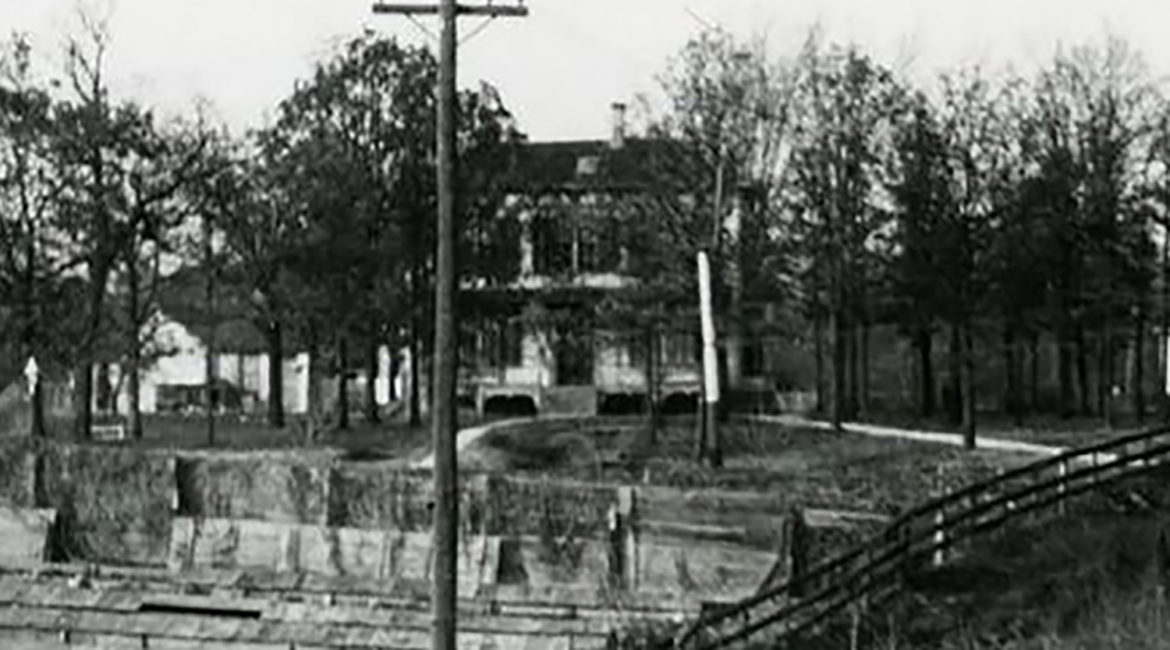
The large two story house now gone I believe would have been 7017 Bruno Ave. (which was previously named Benton Ave. on the STL city side of the road). With the house being on the northern side of Bruno it is unlikely that it is connected to the farm in the picture as Bruno was the dividing line between the adjacent large plots of land and has a different line of ownership. This land in question went to a son of Gratiot and R. Hanriham, then by 1870 was divided into 4 lots. The most easterly lot being twenty acres, bordered by aprox. Glades, Yale, Bruno, and McCausland, was owned by M. Botinger.
In 1910, 7017 Bruno Ave. was being rented by Kathryn Walsh. She was 41, born in Ireland, and married for 20 years with 4 children (she was not listed as a widow). She was not employed. Her sons Eugene, 18 years, worked as a Train? Clerk and Joseph 17 worked as a moulder for a steel works. Daughters Nillie 15 and Margurite 13 were not employed nor attending school. Two male boarders also lived in the household, John Martin 34 worked as a moulder for a steel works and Ben Kessler 21 was a freight handler.
Whew! Nice job, Dave. I knew we could count on you but you’ve outdone yourself on this one.
It is interesting and informative that the Zillow build dates are wrong. Who’d a thought it? The 1909 build dates on the two stone homes are correct. They are nearly identical to the stone home I live in on Big Bend. My home is one of fifteen on the block. It was built in 1910.
The amount of information you were able to provide is amazing. Not the least of which is the bullet-riddled utility pole. I completely missed that. Much thanks.
Couple of blocks away (7237 Bruno) was bought by my grandparents Walter and Lillian Notter in 1930 for the sum of ten dollars according to the original handwritten deed. They lived there and raised all 4 sons (Maplewood High graduates, it wasn’t MRH yet) until my grandmother passed away in 1979. Previously my grandfather lived with his parents at 7516 Woodland or 7511 Woodlawn, Maplewood since 1892 (although it wasn’t Maplewood yet). His WW1 draft induction notice says Woodlawn but other record show Woodland. Wish I could figure out which address is corrrect.
Ed, I get a notification by email when someone comments on my blog. I got the notification for this comment about an hour-and-a-half ago at 9:42 PM. Today is the 28th of June and you commented on the 22nd. What the…?
Anyhow, 10 bucks for a house! Houses weren’t that cheap in 1930. Must have been some other detail we’re lacking like had just recently burned. Send me a copy of that deed and I’ll post it. As for the street name (you probably know this already) it would have to be Woodland if it was in Maplewood. We have no Woodlawn.
Little confused. The web site has Doug Minor’s e-mail but not Doug Houser’s? Where do you want me to send the photo’s to?
You can send them to me at dkhouser @gmail.com. Thanks.
Hi Doug, Great story – we owned the house at 2138 Blendon Place in the 1970’s through the 1989. All three of our children were born in the house. We loved that house and glad it still looks fantastic. Is there a way we can preserve this story?
Thank you,
Steve and Nanette Smith and kids Spencer, Lana and Adam
Thank you for your comments, Smith family. You are welcome to copy this post for your personal use.
I believe that the church in the photo is an earlier version of the church that is currently known as The Gathering (originally Emmanuel Methodist Church). The building that now stands at the corner of Stanley Ave. and McCausland is the second or third church building for that congregation and the prior building (which should be the one in the photo) stood on what is now the parking lot for the existing church building. My great-grandfather was the pastor there in the 1950’s and my grandparents were married there around that time. Due to growth the congregation now worships under a new name in the large new building at 2360 McCausland Ave. (and at multiple other locations around town), and I am currently on staff at the church. Needless to say, this congregation has been proximate to the corner of Manchester and McCausland for a very long time! Really interesting photo. Thanks for posting!
Thank you, Ryan for that very interesting bit of the history of your church. Got any old photos?
There is a large home visible in the first image that has disappeared today. This is a detail that I meant to mention but forgot to do so. It is just to the left of the church. It appears to be a large two story home. Also it may have been the home of the owner of the land on that NW quadrant of the intersection. Possibly he is one of the men in the photo? How about it, records guys? Esley, Dave. Can you find who owned that piece of property, say about 1915?
Just getting my bearings, is the first picture the view looking north on McCausland? That would make the farmers field on the left the location of the BP gas station today.
Hi Todd, Yes and yes.
Great pictures and history! There is a small former church and “Miller Memorial Hall” down the street from the Pfeifer house. It’s at 2152 Blendon Place. Do you know the history?
John, Thank you for the compliment. I don’t know the history of those buildings. Is the Miller Memorial Hall a rock building?
Hi Doug,
Yes, that is the one! I think it may be used as an art studio today?
Are streetcar rails in the picture? Maybe the picture shows rails being placed in the street.
Hi Robert, the streetcar rails in the image are on Manchester Ave. From memory, I believe that streetcar line began operation in 1896. I remember reading about a horse drawn streetcar that turned around at the Wedge in Maplewood. Since this image is post 1913, I have no idea what powered the streetcars this far out then. I think they were electric in downtown St. Louis. I think the men in the photo are farmers. What they’re up to I have no idea. https://40southnews.com/maplewood-history-the-wedge/
Doug,
Can you tell what the black blob is on the telephone pole to the left of the street sign in the first picture? You have a close up of the spot in the photo that you are showing the street lights but it doesn’t look to be as tall as the other street lights in the picture when comparing the white paint on the telephone poles. Also, are those bullet holes in the Manchester sign?
Mike, Congratulations. You rang the bell! See my response and images above. Much thanks for your questions.
Whatever the blob is, it is clearly related to the line coming down from the pole. I wonder if this picture shows development in progress. The line could be power not yet hooked up or something. The items in the cleared field look like some type of Forms. Possibly concrete foundation forms? Maybe that cleared field was soon going to have numerous houses on it and those were forms waiting to be used?
The Telford road is named for the Scottish engineer Thomas Telford (1757-1834), who was one of the greatest figures of the early Industrial Revolution. He improved on the system of road paving pioneered by John Loudon McAdam, which called for three layers: large stones, smaller stones, and a topping of tamped gravel. Telford refined the kinds of stones used based on the anticipated traffic and other conditions and arched the road surface to facilitate drainage of water. Telford designed many bridges for both roads and canals but is probably best known for creating a road across northern Wales to link London to Holyhead on the Island of Anglesey, the shortest route to Dublin. His suspension bridges at Conwy and Menai are still considered masterpieces. His biographer called him “The Colossus of Roads.”
How very interesting, Esley. I suppose that we could advertise Maplewood as having streets designed by the “Colossus of Roads.” Ha. That’s great! As always, much thanks for your input.

Looking at the poles that we think are full of gun shots holes. That may true but you also need to remember that back then most of the work done on those poles would have been done by a guy with a belt around the pole and climbing spikes on his feet and strapped to his calves. He would strap his belt around the pole and then proceed to climb the thing by stabbing his spikes into the pole until he got to the top. Then to come down he would have done it again. Every trip up and down the pole. Would not take but a few trips and the pole is full of holes. Some of those holes may have been that. Now we are used to seeing most of the pole work being done from the back of a truck with a guy in a boom bucket.
Hey Mark, I think everything you say is true. This time anyway. Just kidding. Thank you for providing another possible detail we hadn’t thought of. Hope you are feeling better.
Good point Mark.
I’ve always been amazed at the way so many streets in the metropolitan area change names. Got to be confusing to visitors. My family has been scattered throughout MRH forever. I lived there for 68 years, my grandparents moved into MRH in 1892. Bruno ends at Big Bend and continues East as Folk but W. Bruno picks up 2-3 blocks North at Big Bend. Del Norte/Oakview, Lindbergh/Kirkwood, etc. Has to be wierd if you’re not from the area.
Hey Ed & Sharon, Perhaps most major cities have these same sort of baffling street name changes? They are definitely confusing to someone unfamiliar with the area. Your grandparents moved here in 1892? Hmmm. Got any old photos? Thanks for your comments.
Some of my family at the Bruno address, late 20’s early 30’s. Couple of WW1 photos, my grandfather in Reims, France and the Maplewood VFW “Last man standing” artillery shell casing from WW1 (aside from my grandfather’s name, also J.B. Smith, Odie J. Wilkinson the original name of the Richmond Heights VFW and O.J. Dowd one of the original names of the Maplewood VFW and others. All MRH residents). Copy of the original 1931 charter establishing the Maplewood VFW (eventually became the Maplewood American Legion on Sutton that has since folded). Mid 1940’s at Maplewood HS (it wasn’t MRH yet). And a 1976 of our house painted for the bi-centenial (Richmond Heights sued to make him repaint it white).
Those images sound like they’re right up my alley. If you would care to send me copies I’ll add them to my digital pile. All goes to the Maplewood Library someday. Send them to [email protected]. I am not interested in the American Legion charter. I sorted through about a ton of their stuff when they shut down. You can find the first two posts I did on them at this link.
https://40southnews.com/maplewood-history-the-shaw-stevens-post-103/
This is the link to the third and final post. https://40southnews.com/maplewood-history-the-shaw-stephens-post-103-part-3/
Thanks, I’ve learned something. I always thought the Maplewood American Legion began as a VFW. After your response I dug a little deeper and found that the Maplewood VFW began in 1931 with my grandfather Walter (they messed up his name as William) and Odie J. Wilkinson as Maplewood VFW Post 2203 Dowd-Lane at 7314 Manchester. They merged with Shrewsbury in 1978 and Shrewsbury merged with the now Richmond Heights Post 3500 (the origin name of Richmond Heights VFW Post 3500 was Odie J. Wilkenson Post). I have scans of the original and merge of all these VFWs if you or anyone else is interested. I will gather the other photos and e-mail them to you soon. Switching gears. Some months ago a sent you a photo of my grandfather with the Freddie Kurtzeborn Orchestra (circa 1920?) to try & gather info on the band. One person suggested I contact Ron Elz who might be able to help. I can’t figure out how to contact him. Any suggestions?
Hey Ed, My apologies. I read this and then immediately forgot about it. The email address I have for Ron Elz is [email protected]. I also am not remembering this photo of your grandfather. Could you please send it again? And thank you for all of the interesting images you just sent. I think the readers of this space will find them interesting as well.
Doug, Gary here, maybe I misunderstood Dave’s comments, but in 1960 and long before, McCausland went south of Manchester. I grew up nearby and we drove that route often. McCausland is interesting as it seemingly changes names several times along its length; In the northernmost stretches it is, or merges into Hodiamont, then Skinker to become McCausland, at Canterbury it’s Ellendale and then Wabash, finally at its terminus is McCausland again.
This comment refers to the fact that there was no road connecting the intersection of McCausland Ave. and Manchester Ave. to Southwest Ave. until sometime between around 1955 and 1966. We know this because the aerial photo maps provided by the St. Louis County Property Lookup website show in both the 1937 and 1955 photography maps there is clearly no road present. The road does not appear until the 1966 map. This is corroborated by numerous other early St. Louis maps.
Great photo. I have a few thoughts, guesses and info to add.
The 1913 build dates for the two homes on McCausland appears to be wrong… Both of these homes in the photo are included in the 1903 Sanborn Insurance Maps of St. Louis, Volume 10, Plate 54. The three homes currently south of these two that are clearly not present in the photo have 1909 build dates and are not included in the 1903 Sanborn Map. Thus, I would not be surprised if this picture was a bit older than 1913 and closer to the turn of the century?
Bullet holes galore! I think the street sign was just for the sharp shooters and the novices took aim at that first telephone pole. It appears to be riddled with hundreds of bullet holes not present on the other poles? Must have been the thing to do from the passing traffic? Also the blob next to the first pole with the cable connected… if I had to bet I would put my money on a police call box.
This northern part of McCausland ended here at Manchester and was not connected to the more southern stretch of McCausland until nearly 1960.
This photo is at the eastern edge of the Sutton property line but it did not come this far north. The land the photographer is standing on is actually at the eastern edge of land Charles Rannells purchased from the Gratiot Estate. By 1870 the large lot was subdivided and sold as the East Laclede Subdivision. Catherine P. Rice is listed as owning ten acres on the corner (the farmland in the picture) bordered by Yale to the west and Bruno to the north. By 1912 this 10 acre lot had been split in two properties and both subdivided, with Phillip Scott developing the western half and Kandem? the eastern half.
The large two story house now gone I believe would have been 7017 Bruno Ave. (which was previously named Benton Ave. on the STL city side of the road). With the house being on the northern side of Bruno it is unlikely that it is connected to the farm in the picture as Bruno was the dividing line between the adjacent large plots of land and has a different line of ownership. This land in question went to a son of Gratiot and R. Hanriham, then by 1870 was divided into 4 lots. The most easterly lot being twenty acres, bordered by aprox. Glades, Yale, Bruno, and McCausland, was owned by M. Botinger.
In 1910, 7017 Bruno Ave. was being rented by Kathryn Walsh. She was 41, born in Ireland, and married for 20 years with 4 children (she was not listed as a widow). She was not employed. Her sons Eugene, 18 years, worked as a Train? Clerk and Joseph 17 worked as a moulder for a steel works. Daughters Nillie 15 and Margurite 13 were not employed nor attending school. Two male boarders also lived in the household, John Martin 34 worked as a moulder for a steel works and Ben Kessler 21 was a freight handler.
Whew! Nice job, Dave. I knew we could count on you but you’ve outdone yourself on this one.
It is interesting and informative that the Zillow build dates are wrong. Who’d a thought it? The 1909 build dates on the two stone homes are correct. They are nearly identical to the stone home I live in on Big Bend. My home is one of fifteen on the block. It was built in 1910.
The amount of information you were able to provide is amazing. Not the least of which is the bullet-riddled utility pole. I completely missed that. Much thanks.
Couple of blocks away (7237 Bruno) was bought by my grandparents Walter and Lillian Notter in 1930 for the sum of ten dollars according to the original handwritten deed. They lived there and raised all 4 sons (Maplewood High graduates, it wasn’t MRH yet) until my grandmother passed away in 1979. Previously my grandfather lived with his parents at 7516 Woodland or 7511 Woodlawn, Maplewood since 1892 (although it wasn’t Maplewood yet). His WW1 draft induction notice says Woodlawn but other record show Woodland. Wish I could figure out which address is corrrect.
Ed, I get a notification by email when someone comments on my blog. I got the notification for this comment about an hour-and-a-half ago at 9:42 PM. Today is the 28th of June and you commented on the 22nd. What the…?
Anyhow, 10 bucks for a house! Houses weren’t that cheap in 1930. Must have been some other detail we’re lacking like had just recently burned. Send me a copy of that deed and I’ll post it. As for the street name (you probably know this already) it would have to be Woodland if it was in Maplewood. We have no Woodlawn.
Little confused. The web site has Doug Minor’s e-mail but not Doug Houser’s? Where do you want me to send the photo’s to?
You can send them to me at dkhouser @gmail.com. Thanks.
Hi Doug, Great story – we owned the house at 2138 Blendon Place in the 1970’s through the 1989. All three of our children were born in the house. We loved that house and glad it still looks fantastic. Is there a way we can preserve this story?
Thank you,
Steve and Nanette Smith and kids Spencer, Lana and Adam
Thank you for your comments, Smith family. You are welcome to copy this post for your personal use.
I believe that the church in the photo is an earlier version of the church that is currently known as The Gathering (originally Emmanuel Methodist Church). The building that now stands at the corner of Stanley Ave. and McCausland is the second or third church building for that congregation and the prior building (which should be the one in the photo) stood on what is now the parking lot for the existing church building. My great-grandfather was the pastor there in the 1950’s and my grandparents were married there around that time. Due to growth the congregation now worships under a new name in the large new building at 2360 McCausland Ave. (and at multiple other locations around town), and I am currently on staff at the church. Needless to say, this congregation has been proximate to the corner of Manchester and McCausland for a very long time! Really interesting photo. Thanks for posting!
Thank you, Ryan for that very interesting bit of the history of your church. Got any old photos?
There is a large home visible in the first image that has disappeared today. This is a detail that I meant to mention but forgot to do so. It is just to the left of the church. It appears to be a large two story home. Also it may have been the home of the owner of the land on that NW quadrant of the intersection. Possibly he is one of the men in the photo? How about it, records guys? Esley, Dave. Can you find who owned that piece of property, say about 1915?
Just getting my bearings, is the first picture the view looking north on McCausland? That would make the farmers field on the left the location of the BP gas station today.
Hi Todd, Yes and yes.
Great pictures and history! There is a small former church and “Miller Memorial Hall” down the street from the Pfeifer house. It’s at 2152 Blendon Place. Do you know the history?
John, Thank you for the compliment. I don’t know the history of those buildings. Is the Miller Memorial Hall a rock building?
Hi Doug,
Yes, that is the one! I think it may be used as an art studio today?
Are streetcar rails in the picture? Maybe the picture shows rails being placed in the street.
Hi Robert, the streetcar rails in the image are on Manchester Ave. From memory, I believe that streetcar line began operation in 1896. I remember reading about a horse drawn streetcar that turned around at the Wedge in Maplewood. Since this image is post 1913, I have no idea what powered the streetcars this far out then. I think they were electric in downtown St. Louis. I think the men in the photo are farmers. What they’re up to I have no idea.
https://40southnews.com/maplewood-history-the-wedge/
Doug,
Can you tell what the black blob is on the telephone pole to the left of the street sign in the first picture? You have a close up of the spot in the photo that you are showing the street lights but it doesn’t look to be as tall as the other street lights in the picture when comparing the white paint on the telephone poles. Also, are those bullet holes in the Manchester sign?
Mike, Congratulations. You rang the bell! See my response and images above. Much thanks for your questions.
Whatever the blob is, it is clearly related to the line coming down from the pole. I wonder if this picture shows development in progress. The line could be power not yet hooked up or something. The items in the cleared field look like some type of Forms. Possibly concrete foundation forms? Maybe that cleared field was soon going to have numerous houses on it and those were forms waiting to be used?
The Telford road is named for the Scottish engineer Thomas Telford (1757-1834), who was one of the greatest figures of the early Industrial Revolution. He improved on the system of road paving pioneered by John Loudon McAdam, which called for three layers: large stones, smaller stones, and a topping of tamped gravel. Telford refined the kinds of stones used based on the anticipated traffic and other conditions and arched the road surface to facilitate drainage of water. Telford designed many bridges for both roads and canals but is probably best known for creating a road across northern Wales to link London to Holyhead on the Island of Anglesey, the shortest route to Dublin. His suspension bridges at Conwy and Menai are still considered masterpieces. His biographer called him “The Colossus of Roads.”
How very interesting, Esley. I suppose that we could advertise Maplewood as having streets designed by the “Colossus of Roads.” Ha. That’s great! As always, much thanks for your input.
Great tour and history, Doug!
Thank you, Ralf. Always good to hear from you.
Comments are closed.